
After a day's journey of 18 miles in a direction we encamped in the midst of another very basin at a camping ground called las Vegas a term the Spaniards use to signify fertile or marshy plains in contradistinction to llanos which they apply to dry and plains [sic]...Excerpt from John C. Fremont's diary entry, May 3, 1844, from Map of an Exploring Expedition to the Rocky Mountains in the Year 1842 and to Oregon & North California in the Years 1843-44
Special Collections has a significant collection concerning the exploration of the American west, southwest, Nevada and Southern Nevada. This collection contains the original published reports of the great 19th century western surveys conducted by the U.S. government, travel accounts and diaries as well as the great series of maps and atlases that accompanied the published accounts. These reports covered all fields of 19th century natural science and contained artist renderings of the region's physical characteristics as well as its flora and fauna. The perceived potential for the agricultural development of the west prompted considerable study of the region's hydrogeology and the feasibility of irrigation. These reports were published voluminously in the USGS annual reports and in the official reports of specific expeditions.
Pacific Railroad Survey, 1855-60
Reports of explorations and surveys, to ascertain the most practicable and economical route for a railroad from the Mississippi River to the Pacific Ocean / made under the direction of the secretary of war, in 1853-[6] .. Washington : A.O.P. Nicholson, Printer [etc.], 1855-60 F593 .U58
Colorado River, 1857-8
United States. Army. Corps of Topographical Engineers. Report upon the Colorado River of the West : explored in 1857 and 1858 by Joseph C. Ives Washington: Govt. Print. Office. 1861 F788 U59
Arid Regions, 1879
Powell, John Wesley, Report on the lands of the arid region of the United States : with a more detailed account of the lands of Utah. With maps / by J. W. Powell Washington: Government Printing Office, 1879 2d ed HD1671.U5 P68 1879
Great Salt Lake, 1853
United States. Army. Corps of Topographical Engineers Exploration and survey of the valley of the Great Salt Lake of Utah, including a reconnaissance of a new route through the Rocky Mountains. By Howard Stansbury, captain, Corps topographical engineers, U.S. Army. Printed by order of House of representatives of the United States Washington, R. Armstrong, public printer, 1853 F826 .U559
Mexican Boundary Survey, 1846-7
Notes of a military reconnaissance from Fort Leavenworth, in Missouri, to San Diego, in California, including parts of the Arkansas, Del Norte, and Gila rivers. By W. H. Emory, brevet-major, corps topographical engineers. Made in 1846-7, with the advanced guard of the "Army of the west." Washington, Wendell and Van Benthuysen, printer, 1848
Map of the United States and their territories between the Mississippi and the Pacific Ocean and part of Mexico / compiled from surveys made under the order of W.H. Emory; and from the maps of the Pacific Rail Road, General Land Office, and the Coast Survey; projected and drawn under the supervision of Lt. N. Michler, by Thomas Jekyll ; engraved by Selmar Siebert; UNLV Spec Maps; G4050 1857 .J44
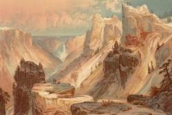
Surveys west of the 100th Meridian,1874-5
Report upon United States Geographical surveys west of the one hundredth meridian / in charge of First Lieut.Geo. M. Wheeler ... under the direction of the chief of engineers, U.S. Army. Published by authority of ... the secretary of war in accordance with acts of Congress of June 23, 1874, and February 15, 1875. In seven volumes and one supplement, accompanied by one topographic and one geologic atlas ..
Washington, D.C. : Government Printing Office, 1875-89 v. 1-7, Appendix F, 2 atlases; QE 74 W6
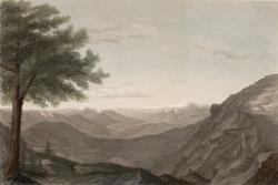
Geological Exploration of the Fortieth Parallel, 1867-69
Report of the geological exploration of the fortieth parallel / made by order of the secretary of war according to the acts of congress of March 2, 1867, and March 3, 1869, under the direction of ...A. A. Humphreys, chief of engineers, by Clarence King, U.S. geologist, [Washington : Government Printing Office, 1870-80] Atlas QE74 .K5
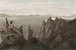
Fremont's Expedition to the Rocky Mountains, 1842-4
Report of the exploring expedition to the Rocky Mountains in the year 1842 : and to Oregon and north California in the years 1843-44 / by Brevet Capt. J.C. Fremont ; under the orders of Col. J.J. Abert, Chief of the Topographical Bureau ; printed by order of the House of Representatives. Washington : Blair and Rives, Printers, 1845 F592 .F83 1845
Map of an exploring expedition to the Rocky Mountains in the year 1842 and to Oregon & north California in the years 1843-44 / by Brevet Capt. J.C. Fremont of the Corps of Topographical Engineers under the orders of Col. J.J. Abert, Chief of the Topographical Bureau ; lith. by E. Weber Co., Baltimore, Md [Washington, D.C. : U.S. Senate, 1845] UNLV Spec Maps G4051.S12 1844 .F742